 |
View of the Tripyramids from the Hi-Cannon Trail.
I-93 can be seen below. |
Cannon is a giant albatross of a mountain, located on the northwest end of Franconia Notch. It’s not at all shaped like a pointy triangle, so from the highway, examining its sprawling girth, I never really understood exactly where the summit might be. But if you look closely, you can see a fire tower positioned on the official summit. Approaching from 2,100 feet below, I gaze up at the fire tower and think, “I will be up there later today.” It’s an incredible thought.
I am lucky enough to have the chance to hike on a Monday afternoon, avoiding the usual weekend overcrowding that plagues the Notch. Even so, the parking lots are full and I ended up pulling onto the grass alongside the exit ramp for the parking area. But the Notch has lots of different hiking and biking trails, and crowds tend to disperse among the trees. As it turns out, I only see five other people hiking on the trail.
 |
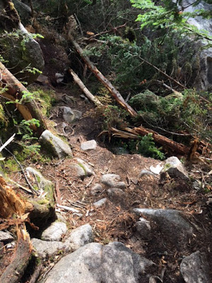
View from the Hi-Cannon Trail. The ladder near the bottom
of the photo is part of the trail. |
Using Steven Smith’s guide
The 4,000 Footers of the White Mountains, I decide to begin from the
Lafayette Campground, ascend via the Hi-Cannon Trail, and then, if I think there is enough time, descend on the Kinsman Ridge Trail, intersecting for a final descent on Lonesome Lake Trail. The Hi-Cannon Trail looks like it might be the more difficult trail, but I figure I can handle it.
Within the first 30 minutes, I am not sure if I can handle it. The air
is muggy and I’m feeling a little lightheaded. I have to stop and wait
for the mental fog to clear before using both hands and feet to lift
myself up a root-covered boulder. The trail climbs steeply through the
trees, with several parts of the trail damaged by erosion, making the
footing uncertain. Pretty soon my face is slick with sweat, my cotton
headband soaked. I am so out of shape. I’m not sure if I can do this
after all. One step at a time. I am a mountain goat. I can do this. When
I reach that rock, I will stop to rest.
When I reach that rock, I decide to sit for a real rest. I eat some gorp and look at the trail map. There’s a fork not too far ahead. If I really feel bad from there, I can always descend on the adjoining trail. My damp body is cooling down; it’s time to start moving again. I can do this.
And I do. When I reach the fork, all the clouds in my head are gone. I’ve found my trail legs. The worst is behind me, and I hike the rest of the trail to the summit with relative ease. Near the summit, there’s a crossroads of trails where folks who ride the
Cannon Mountain Aerial Tramway emerge for the short walk to the fire tower on the summit. They look neat and clean in their street clothes and fashionable shoes. Some puff with effort as they climb the wide stairs of the fire tower. Most of them are not from America, except for a group of Hasidic Jews. I smile to myself. With the men in overcoats and the women in thick stockings, they, at least, are dressed for the cold wind blowing on the summit.
 |
| View from the summit fire tower. |
The fire tower isn’t exactly a restful place, so after a few moments of internal celebration and recording the view, I climb down the stairs and find a stone bench near the fire tower. Regretfully, I didn’t bring my usual bag of celebratory
peanut M&Ms, but I do enjoy some chocolate yogurt-covered raisins. It’s about 4:30pm; time to head back down the mountain.
At the fork where Hi-Cannon and Kinsman Ridge trails meet, I encounter a hiker with a facial expression I can’t quite identify. She appears both annoyed and resolute. “Are you hiking the Kinsman Ridge?” she asks me. Yes. “Have you hiked it before?” Well, no, I tell her. “Be really careful,” she says. “Really careful. It’s really, really rough.” Um, okay. I will, thanks for the warning!
I begin to descend and wonder what in the world she was talking about. The trail is somewhat steep, with large boulders to navigate, but it’s not too bad. After all, it is the White Mountains, I think to myself. They’re not easy. The trail becomes steeper. Many times, I use my hands to hold my body aloft between two large boulders, slowly lowering myself down to the rock below. Okay, this really is getting difficult. I am suddenly really glad I didn’t hike up this way. I look behind me at the trail of boulders, seemingly climbing straight up. I mutter an expletive. The topo map totally didn’t indicate the trail would be this steep. I sit on my butt and slowly scooch down to the next boulder below. It’s fun, but it’s hard. I am so glad I didn’t hike up this way.
 |
| Damage on Kinsman Ridge Trail. |
And then I see what she was talking about. The trail ahead seems to disappear in a thicket of broken trees and cut limbs. Clearly, a storm caused some damage here, and while the trail was rudely cleared, it’s not at all the typical tramped surface. The trail turns hard left and for about eight feet, skirts a granite rock face, the narrow path dropping quickly to the right. A water bottle lies abandoned several feet below. I turn with my back to the water bottle and, with my hands on the rock face, step carefully to safety. Okay. Yeah. This is sketchy. The path ends in the rocks, and I assume I’m on the trail again, but it’s hard to know for certain. I must still be on the trail, I think. There’s no where else to go.
Eventually I see a faded blue blaze on a tree, and with renewed confidence I continue down the rocky trail. It rained pretty steadily during the past couple of days, and the trail is wet and slippery. I wonder if it seems more slippery now because I am descending, or if this trail is made of different stuff? My hiking boots slip and stumble on the rocks. Out of nowhere, my left foot slides out from under me and I am airborne. By some miracle, I glide to the left and land on my butt — and my backpack — on a soft bed of dirt and hemlock needles. Well, that could have been a lot worse, I tell myself. Okay. Let’s keep it slow and keep going.
It usually takes much less time to descend a mountain than it does to climb one, but not today. After a while, I start to wonder where in the world I am. I should have reached the junction by now that would direct me to Lonesome Lake. Where is it? I’ve hiked for a while. I review the description of the trail, but it doesn’t really help. What the heck. Knowing Google Maps is virtually useless on hiking trails, I try it anyway and discover that I can, at least, see my position relative to the lake. It appears as though I’m where the trail junction should be. I must be pretty close.
The trail has moderated to a gentle descent through soft dirt and the occasional rock — no more large slippery surfaces to negotiate — so I descend quickly, wondering where I am. What would happen if I missed the junction? Where would I end up? Would I still be able to get back to the car before dark? I do have a flashlight, which is some relief. Mostly I am concerned the trail might start climbing again. If it does that, I will know I screwed up. But really, the best thing to do, even if that happens, is keep hiking until I find a landmark I recognize. I keep going.
 |
| Lonesome Lake |
The ground is starting to become marshy, and a log walkway appears ahead. The walkways around Lonesome Lake! I think in excitement. But wait. How did I get here? I don’t remember the junction where I would turn to hike down to the lake. But this must be it. Sure enough, in just a couple of minutes the lake appears through the trees. It’s been years since I’ve been here; the popularity of the area has kept me away. The last time was in 2010, on a foggy, misty, chilly day. On that day, I couldn’t see where the lake ended and the fog began. Today the view is crystal clear. A rhythmic banging begins, a loud chanting from across the lake. It must be dinnertime at the
hut, I realize. Sure enough, my phone reads exactly 6pm.
 |
The Kinsman Ridge/Lonesome Lake Trail junction.
I completely forgot I went through it. |
I take a moment to flip through the photos I took along the way, and discover, to my amazement, a photo of the sign at the junction I thought I’d missed. I’m thoroughly confused; I don’t remember this at all. I must have bonked, I say out loud to myself. I’ve never really done that before.
Fortunately, I know the way forward is easy now; the trail between the campground and the hut is well trodden. I am back at my car at 6:45pm. The balls of my feet are sore, and I can’t wait to put my sandals on. I’m still a little confused about what happened, but, I did it. Despite not being in very good hiking shape yet, I hiked Cannon, and next week I can hike another mountain. My hiking season has officially begun.


